Search results
Mar 27, 2023 · Explore the geography, history, and culture of Ontario, Canada's most populous province. Find maps of its regions, cities, lakes, rivers, and borders with the US and other provinces.
- Ontario Flag
Ontario Flag DESCRIPTION The flag of Ontario was officially...
- Ontario Symbols
Printable map of Ontario and info and links to Ontario...
- Quebec
Quebec, the largest Canadian province, encompasses an area...
- Ontario Flag
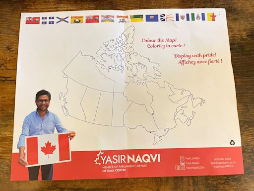
Ontario Liberal MP's map of Canada forgets P.E.I., Yukon
Yasir Naqvi's map of Canada map depicts a country Canadians are not familiar with — it has eight provinces and two territories.
CBC via Yahoo
5 days ago
Severe thunderstorm, rainfall warnings lifted for Ottawa-Gatineau
Environment Canada has lifted the second of two severe thunderstorm warnings issued Sunday for the Ottawa-Gatineau area.As of 7 p.m., the latest storm had passed through the ...
CBC via Yahoo
7 days ago
Ontario Map - Canada. Ontario is Canada's second-largest province, and the most populous, with more than 14 million inhabitants. It is home to the Canadian capital city of Ottawa, and Toronto, which is Ontario's capital and Canada's largest city. Map. Directions. Satellite. Photo Map. ontario.ca. Wikivoyage. Wikipedia. Photo: Ptrbnsn, CC BY-SA 3.0.
Nov 10, 2023 · Find various maps of Ontario, the most populous province in Canada, with cities, towns, highways and roads. Learn about the location, area, population and capital of Ontario.
Find local businesses, view maps and get driving directions in Google Maps.
View and print the detailed Ontario map, which shows major roads and population centers, including the Ontario capital city of Toronto. Zoom in and out, and switch to full-screen mode for enhanced readability.
Jun 8, 2024 · Find an Ontario map with major highways, roads, lakes, rivers, and cities of the most populous province in Canada. Explore satellite imagery, elevation map, and geographical regions of Ontario.
Download or order a copy of Ontario's official road map, which includes highways, roads, municipal borders, travel information and more. View and download PDFs of southern and northern Ontario maps and inset maps for selected municipalities.


